Shey Phoksundo Lake Trek
13 days to Nepal's deepest lake, through the Suli Gad gorge into Bon country
13-Day Shey Phoksundo Lake Trek
The Shey Phoksundo Lake Trek is a 13-day trip starting and finishing in Kathmandu. The high point is a ridge at 3,780 m above the lake, and a normal day is 4 to 6 hours of walking. It is the gentlest way into Dolpo and the only one that runs on teahouses the whole way.
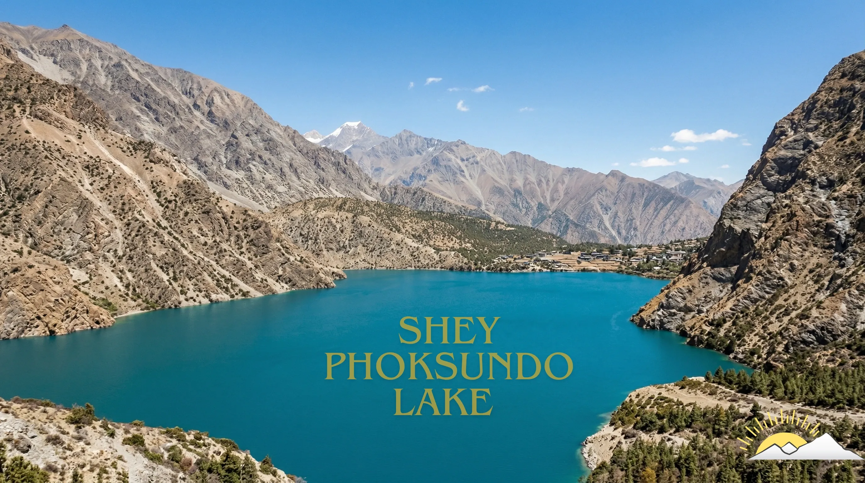
Phoksundo is the deepest lake in Nepal at around 145 m, and the colour is the thing people come for. It sits at 3,640 m in a bowl of cliffs, with the Bon village of Ringmo on its shore and a waterfall at the outlet that drops the better part of 160 m.
The walk in follows the Suli Gad gorge for three days, climbing through pine and birch with the river always below you. Nothing about it is technical. What makes it a real trip is the remoteness: the only way in is the flight to Juphal, there is no road, and the villages north of Chhepka are small and far apart.
This is the Dolpo trek for people who want the lake and the Bon culture without crossing a 5,000 m pass. If you want the passes, look at our Lower Dolpo Trek, and if you want Shey Gompa and the Crystal Mountain, look at Upper Dolpo.
Trip Summary
Duration
Difficulty
Max Elevation
Start point
End point
Daily Activity
Group Size
Best Season
Trip Outline
- Day 1Arrival in Kathmandu
- Day 2Kathmandu to Nepalgunj
- Day 3Fly to Juphal and trek to Dunai
- Day 4Dunai to Chhepka
- Day 5Chhepka to Rechi
- Day 6Rechi to Ringmo and Phoksundo Lake
- Day 7Ringmo and Phoksundo Lake
- Day 8Ringmo to Chhepka
- Day 9Chhepka to Juphal
- Day 10Fly Juphal to Nepalgunj and on to Kathmandu
- Day 11Spare day in Kathmandu
- Day 12Kathmandu at leisure
- Day 13Departure
Included
- Teahouse accommodation on the trek, twin share
- All meals on the trek, breakfast, lunch and dinner, prepared or ordered for you at the lodges
- Lower Dolpo restricted area permit and Shey Phoksundo National Park entry fee
- Airport pick-up and drop-off in a private vehicle
- Kathmandu hotel on bed and breakfast basis
- Kathmandu to Nepalgunj and Nepalgunj to Juphal flights, and the return
- One night in Nepalgunj with breakfast on the outbound leg
- All restricted area permits and national park entry fees
- Government-licensed English-speaking guide, a long-term team member rather than a freelancer
- Porters or pack animals for your duffel, with their insurance, wages, food and equipment
- Staff insurance, domestic flights and transfers for the crew
- Comprehensive first aid kit, pulse oximeter and a satellite communication device carried by the guide
- Trekking Team duffel bag and route map
- All government and local taxes
Not Included
- International flights to and from Kathmandu
- Nepal visa, available on arrival at Kathmandu airport
- Travel insurance, which must cover helicopter evacuation above 5,000 m and is compulsory on this trip
- Lunches and dinners in Kathmandu and Nepalgunj
- Personal trekking equipment, sleeping bag and down jacket, both available to rent in Kathmandu
- Supplementary oxygen, which is always an extra and never included
- Drinks, snacks bought on the trail, hot showers and device charging
- Tips for the guide and crew
- Any cost arising from a flight delay, early return or evacuation
Get started on your journey
Detailed itinerary
Arrival in Kathmandu
Met at Tribhuvan International Airport and driven to your hotel. In the evening we meet to go through the route day by day, check your kit and answer questions.
Dolpo trips carry more paperwork than most. If anything is missing from your documents there is time to sort it tomorrow.
Altitude: 1,400 m.
Travel duration
Elevation
Meal
Accommodation
Kathmandu to Nepalgunj
A short morning flight southwest to Nepalgunj on the Terai plain, close to the Indian border. The change is abrupt. You leave a hill city at 1,400 m and land in flat, hot farmland where the air is thick and the evening smells of dust and diesel.
The Juphal flight leaves early, so staying here is not optional. Use the afternoon to repack: what flies to Juphal is strictly weight limited.
Altitude: 150 m. Flight: about 1 hour.
Travel duration
Elevation
Meal
Accommodation
Fly to Juphal and trek to Dunai
The flight to Juphal is the one everybody remembers. Thirty five minutes in a small aircraft, climbing out of the plain and into the Bheri gorge, then a landing on a strip cut into the hillside.
From the airstrip the trail drops through terraced fields to the Thuli Bheri and follows it upstream to Dunai, the district headquarters of Dolpa. It is an easy first afternoon and a gentle way to start moving.
Altitude: 2,140 m. Distance: 4 km. Walking: 2 to 3 hours.
Travel duration
Elevation
Meal
Accommodation
Dunai to Chhepka
A long day up the Suli Gad, the river that drains Phoksundo. The trail crosses to the west bank and climbs steadily through pine and walnut, past the national park checkpost at Sulighat where your permits are recorded.
The gorge narrows as you go. By Chhepka you are properly inside the park and the villages have thinned out to a handful of lodges.
Altitude: 2,670 m. Distance: 14 km. Walking: 5 to 6 hours.
Travel duration
Elevation
Meal
Accommodation
Chhepka to Rechi
More of the Suli Gad, steeper now, with the river loud below and blue pine giving way to birch. You pass the waterfall that most people stop for, a long thin fall coming off the cliff on the far bank.
The climb is persistent rather than brutal. This is the day your body starts to notice altitude, so we keep the pace deliberately slow.
Altitude: 3,110 m. Distance: 13 km. Walking: 5 to 6 hours.
Travel duration
Elevation
Meal
Accommodation
Rechi to Ringmo and Phoksundo Lake
A short day with a sting in it. The trail climbs a steep spur to a ridge at about 3,780 m, and from the top the lake appears all at once, a sheet of turquoise held between cliffs.
From the ridge you drop into Ringmo, a Bon village of flat-roofed stone houses and mani walls, and camp or lodge within walking distance of the shore. The colour of the water is not a trick of the camera. It comes from the minerals in the rock and it changes through the day.
Altitude: 3,640 m. Distance: 5 km. Walking: 3 to 4 hours.
Travel duration
Elevation
Meal
Accommodation
Ringmo and Phoksundo Lake
A full day at the lake. You can walk the old trail along the western cliff, the one cut into the rock face that appears in Eric Valli's film Himalaya, or visit Thasung Tsholing, the Bon monastery at the far end, or simply sit.
Bon predates Buddhism in Tibet and Dolpo is one of the few places where it is still the everyday religion rather than a curiosity. Walk the mani walls clockwise and you will be doing it the local way.
Altitude: 3,640 m. Walking: 2 to 4 hours, as much as you want.
Travel duration
Elevation
Meal
Accommodation
Ringmo to Chhepka
Back over the ridge for a last view of the lake, then the long descent down the Suli Gad. Going down is quicker but harder on the knees, and the air thickens noticeably as you lose height.
Altitude: 2,670 m. Distance: 19 km. Walking: 6 hours.
Travel duration
Elevation
Meal
Accommodation
Chhepka to Juphal
The final walking day. Down the gorge to Sulighat, across the Thuli Bheri and up the long climb to the airstrip at Juphal.
The climb at the end is unwelcome after a week of walking but it puts you at the airport for a morning flight, which is what matters.
Altitude: 2,475 m. Distance: 17 km. Walking: 6 to 7 hours.
Travel duration
Elevation
Meal
Accommodation
Fly Juphal to Nepalgunj and on to Kathmandu
An early flight off the shelf to Nepalgunj, then a connection to Kathmandu. You are usually back in the city by mid afternoon.
Altitude: 1,400 m. Flights: about 1 hour 40 minutes in total.
Travel duration
Elevation
Meal
Accommodation
Spare day in Kathmandu
This day exists because Juphal flights cancel. If everything ran on time it is yours: Patan, Boudhanath, the shops in Thamel, or nothing at all.
Altitude: 1,400 m.
Travel duration
Elevation
Meal
Accommodation
Kathmandu at leisure
A second buffer day and a chance to see the valley properly. We can arrange a guided walk through Bhaktapur or Patan if you want one.
Altitude: 1,400 m.
Travel duration
Elevation
Meal
Accommodation
Departure
Transfer to the airport about three hours before your flight.
Altitude: 1,400 m.
Travel duration
Elevation
Meal
Accommodation
Ready to start your journey?
Start planning your dream trip today. Enquire now for more information or customize this trip to tailor it to your needs and make it truly unforgettable.