Annapurna Circuit Trek: Complete Guide 2026 | Trekking Team
Introduction
A Path That Has Always Meant Something
There are trails in the world that exist because someone needed to get somewhere, and there are trails that seem to have been put there by the mountains themselves , a gift, or perhaps a test. The Annapurna Circuit is both. Long before the first Western trekker pulled on a boot and stepped out of Besisahar with a head full of wonder and a body not quite sure what it had signed up for, this route was a living artery , a highway of salt, grain, wool, and exchanged wisdom threading between the Hindu lowlands of the Marsyangdi Valley and the Tibetan plateau beyond Thorong La.
People have always walked this circuit. What has changed, across centuries and particularly across the last six decades, is who walks it, why they walk it, and what they find when they do. The circuit itself : the mountains, the river gorges, the high-altitude desert plateau, the rhododendron forests remains largely unchanged. The Annapurna massif does not notice the debate about jeep roads. Thorong La at 5,416 meters does not care about smartphone reception. The butter lamps still burn in the Manang monastery. The yaks still graze the high meadows above Yak Kharka with complete indifference to the changing world below.
This is the story of that continuity, and of that change. It is a story about one of the genuinely great landscapes on Earth, about the cultures that grew inside it, and about a route that has become, for hundreds of thousands of people across generations, one of the defining experiences of their lives.

Origins
Before the Trekkers Came: Ancient Routes and Mountain Kingdoms
To understand the Annapurna Circuit, you have to begin at least a thousand years before the first camera shutter clicked on the south face of Annapurna I. The high valleys of what is now the Annapurna Conservation Area were not empty, windswept wilderness waiting for an intrepid explorer to discover them. They were populated, farmed, traded through, and governed with a sophistication that most visitors passing quickly through on a 17-day trek barely have time to recognize.
The Marsyangdi Valley and the trans-Himalayan corridor over Thorong La formed one of the significant salt-trade routes between the Tibetan plateau and the lower hills and plains of Nepal. Tibetan salt harvested from the vast salt lakes of western Tibet was carried south by traders, many of them Bhotiya communities whose identity, economy, and culture was shaped entirely by the seasonal movement of goods across the high passes. Grain, spices, tools, and cloth came north in exchange. The teahouses and lodges that today serve dal bhat and apple pie to trekkers stand on ground that was once the resting place of salt caravans.
The kingdom of Mustang technically Lo Manthang, a restricted kingdom that still functions in modified form today controlled the upper section of this trade corridor for centuries. Its influence extended across the Kali Gandaki Valley and the high plateau above Muktinath, a fact that explains why the architecture, food, religious customs, and physical appearance of the people of upper Manang feel so distinctly Tibetan even though they have lived within Nepal's borders for generations. 
The First Western Footsteps
The Annapurna massif was first seriously mapped and climbed in the mid-20th century, when Nepal opened its borders to outsiders for the first time in 1950. Maurice Herzog's French expedition made the first ascent of Annapurna I in June 1950 , the first 8,000-meter peak ever climbed an achievement that arrived with nearly catastrophic human cost and was documented in Herzog's book Annapurna, which became one of the best-selling mountaineering accounts ever written and introduced a generation of European and American readers to the name of these mountains.
But climbing a mountain and walking around it are very different endeavors, and the circuit route as a trekking trail was not opened to foreigners until 1977. For nearly three decades after Herzog's summit, the Annapurna region remained largely off-limits to visitors and the villages, valleys, and passes that would become the world's most famous trek continued to live quietly on their own terms.
When trekking permits were finally issued in the late 1970s, the early visitors found something that is now almost impossible to recreate: a landscape and a culture that had developed entirely without an audience. There were no lodges built for Western guests. There were no menus offering pasta and hot chocolate. The trails were the same rough paths used by villagers and traders for generations. Those early trekkers carried everything on their backs, camped in fields and courtyards, and navigated by word of mouth and rough sketch-maps. The circuit they walked was harder, colder, and more uncertain than what exists today. It was also, many of them say, extraordinary in a way that is difficult to separate from the rawness of those conditions.
Decades of Change
The Evolution of the Circuit: Decade by Decade
The Annapurna Circuit has been one of the most documented transformations in adventure travel. Its evolution mirrors broader global shifts in how people move, what they expect when they travel, and what relationship they want with the places and communities they pass through.
1977 – Early 1980s : The Pioneer Era
Nepal opens the Annapurna region to trekkers. The first visitors are predominantly European and American adventurers with significant outdoor experience. No lodges, no established teahouse network, and no circuit identity. Trekkers are guided by local porters and navigational instinct. Numbers are tiny - a few hundred per season. The villages regard them with curiosity.
Mid 1980s : The Teahouse Revolution Begins
Entrepreneurial families along the route, particularly in Manang and Pisang, begin converting rooms and building simple lodges. The Annapurna Conservation Area Project (ACAP) is established in 1986, one of the world's first integrated conservation and development programs, specifically designed to channel trekking revenue into community benefit. Trekker numbers grow to a few thousand annually.
1990s : The Golden Age of the Circuit
The Annapurna Circuit earns its reputation as the world's greatest trek. Word spreads through guidebooks - particularly the Lonely Planet Nepal guide - and the circuit becomes a bucket-list destination for an entire generation of 20 and 30-somethings from across the globe. Teahouse networks become comprehensive. Trekker numbers exceed 50,000 annually. The route's classic three-week format becomes established.
2000s : Road Construction and the First Controversies
The construction of motor roads through the Marsyangdi Valley and later the Mustang-side valley begins changing the circuit fundamentally. What were full trekking days become optional jeep legs. The debate begins among trekkers, guides, and conservationists about what the Annapurna Circuit actually is if large sections can be driven. The route fragments into different experiences for different travelers.
2015 : The Earthquake and the Aftermath
The April 2015 Gorkha earthquake (7.8 magnitude) devastates Nepal and deals a severe blow to tourism. Several villages on the circuit sustain damage and trekker numbers collapse. Nepal rebuilds with extraordinary resilience. The circuit reopens relatively quickly, but the tourism ecosystem takes two to three years to fully recover. Many lodges upgrade significantly during the rebuild period.
2017 – 2019 : Record Numbers and New Questions
Trekker numbers on the Annapurna Circuit reach all-time highs, exceeding 160,000 annually across the Annapurna region. The circuit faces genuine over-tourism pressure at Thorong La and in Manang during peak season. Simultaneous discussion erupts about sustainable carrying capacity, waste management, and the social impact of mass trekking on traditional communities.
2020 – 2022 : Pandemic and a Rare Silence
COVID-19 closes Nepal's borders for the longest uninterrupted period since 1950. The circuit goes silent. Guides, porters, and lodge owners face severe economic hardship. Paradoxically, the trail environment benefits less waste, wildlife returning to sections near the main trail, vegetation recovering in heavily used campsites. The silence becomes, for conservation researchers, an unexpected opportunity.
2023 – Present : The Renewed Circuit
Nepal reopens and trekkers return with a noticeably different energy : more considered, more prepared, more aware of responsible travel. The debate about road construction continues as new sections extend further. The circuit's identity is increasingly defined by the sections that roads cannot touch: the high passes, the Manang valley, the Thorong La crossing, and the timeless villages above 3,500 meters.

The Marsyangdi Gorge: Where the Circuit Announces Itself
Few moments on any trekking route in the world match the first hour out of Chame, when the Marsyangdi Valley suddenly tightens into a gorge so narrow that sheer granite walls rise hundreds of meters on either side and the river, far below, is reduced to a white thread of sound. It is disorienting in the best possible way you are inside a mountain rather than walking past one. The trail pushes through this gorge with sections blasted directly from the cliff face, and the scale of the geological forces that carved it out is written in the rock layers visible above the waterline.
The gorge is a geographic consequence of the collision between the Indian and Eurasian tectonic plates , a process still actively underway, which is why Nepal sits in one of the highest seismic risk zones on Earth. The Annapurna massif itself is young in geological terms, still rising a few millimeters each year even as erosion works to bring it back down. The Marsyangdi has cut its gorge by eroding downward almost exactly as fast as the mountains have risen, which is why the river still flows at close to sea level while the mountains above it have reached 8,091 meters.
The Rain Shadow Desert: Nepal's Hidden Tibet
The transition from the forest zone above Pisang to the high plateau of Manang district is one of the most startling ecological shifts available to any long-distance walker on Earth. It happens over perhaps four hours of walking, and it is comprehensive. The trees disappear. The humidity drops. The vegetation flattens into sparse alpine grass and thorny shrubs. The villages change from wooden-balconied farmhouses to flat-roofed stone towers. The people change. The food changes. Even the light changes it becomes sharper, thinner, more intense, because there is less atmosphere above you to scatter and soften it.
This transformation is the direct consequence of the Annapurna massif acting as a wall against the Indian monsoon. Moisture-laden air pushing north from the Bay of Bengal hits the southern face of the Annapurna range and dumps most of its water on the lower slopes which is why those slopes are among the most densely forested in Nepal, and why the Pokhara Valley, just south of the range, is one of the wettest places in Asia. By the time air crosses the high passes and descends into the Manang and upper Mustang valleys, it has lost its moisture entirely. The landscape on the north side of the Annapurna range receives less than 300 millimeters of rain per year , comparable to parts of the American Southwest. It is, climatically and culturally, the Tibetan plateau.
Thorong La: The Pass That Defines the Circuit
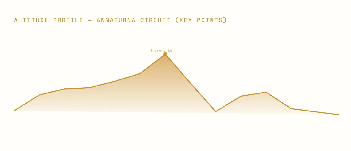
Everything on the Annapurna Circuit is preamble to Thorong La, and everything after it is denouement. The pass at 5,416 meters is not technically the highest point reachable by trekkers in Nepal - several Himalayan viewpoint hikes go higher but it is the highest trekking pass in the world, and it sits at the climactic center of a 17-day journey in a way that gives it a psychological weight that pure altitude cannot explain.
The pre-dawn start from Thorong Phedi or High Camp typically at 4:00 to 5:00 AM, with temperatures well below freezing and a sky still fully dark , is one of the great rituals of Himalayan trekking. Headlamps move across the hillside in the darkness like a slow procession. The trail switchbacks relentlessly upward for three to four hours. Conversation becomes sparse and eventually stops. Breathing is effortful. The body reduces to the next step, the next breath, the ground directly in front of the boot.
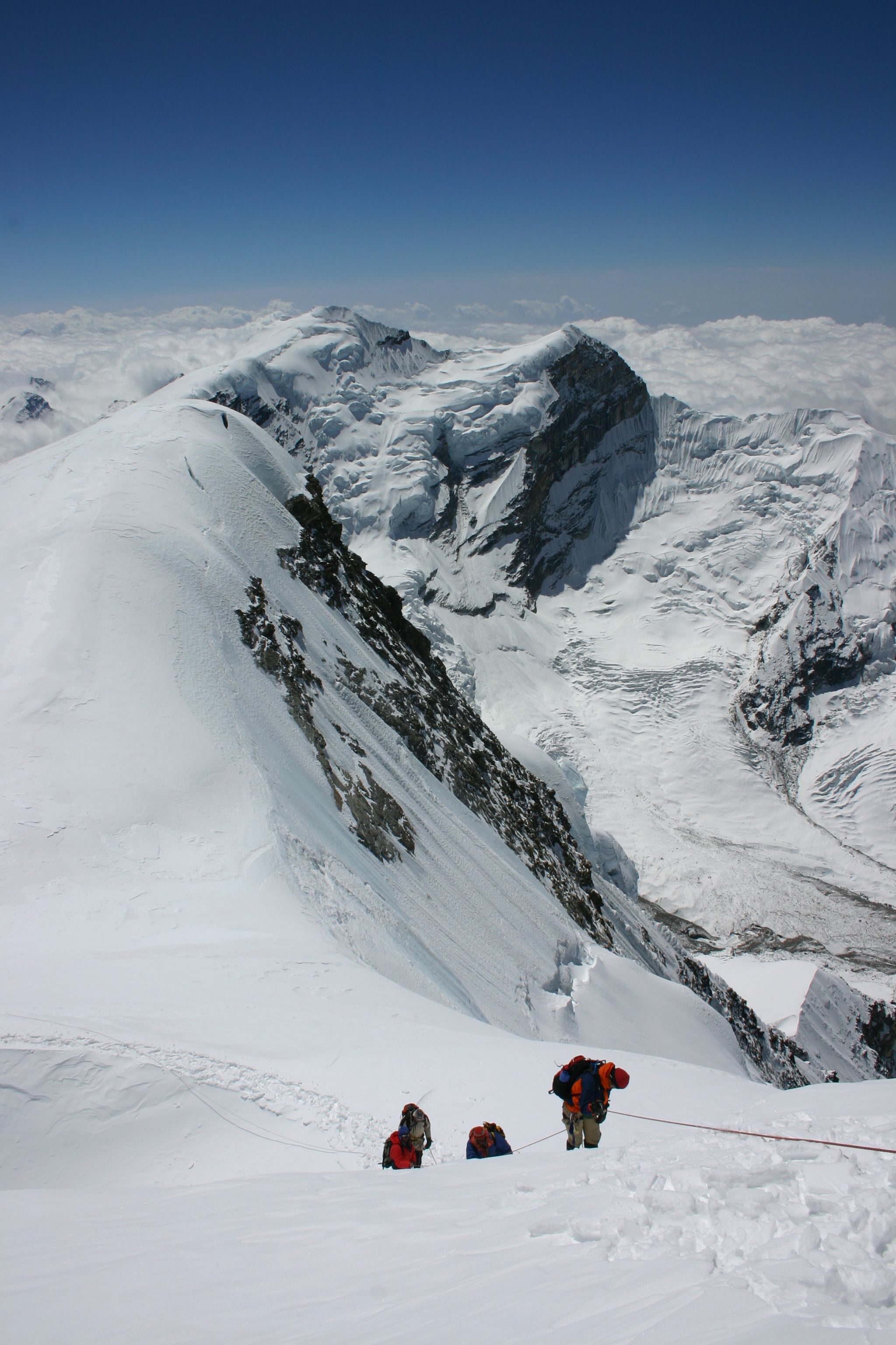
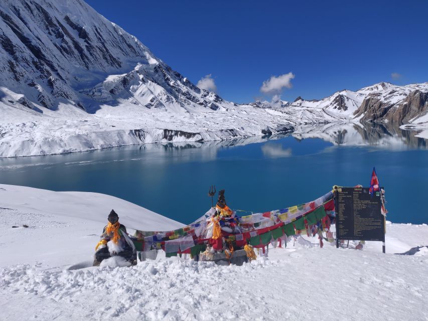
And then the pass. Prayer flags by the thousands, strung between poles and cairns and anything else that will hold them, streaming and snapping in the wind that never stops at 5,416 meters. A board announces the altitude in letters that seem almost comically insufficient. And then the mountains: Thorong Peak, Yakawa Kang, the white wing of Annapurna's north face, and to the southwest visible on the clearest mornings , the unmistakable wedge of Dhaulagiri. Few moments in trekking anywhere match it.
Living Traditions
The Culture of the Circuit: Old Faiths, Old Practices, Enduring Identity
The Annapurna Circuit does not pass through a culturally uniform region. It moves through a series of distinct communities whose religious practices, languages, food traditions, architecture, and social structures differ significantly from one valley to the next. This diversity is one of the circuit's least-advertised and most rewarding dimensions. It is also one of the aspects most at risk from the homogenizing pressures of tourism.
The Gurung People
The indigenous inhabitants of the Annapurna foothills , Ghandruk, Ghorepani, and the villages of the lower circuit - the Gurung people have maintained a distinct cultural identity for centuries. Known internationally for their service as Gurkha soldiers, the Gurung are at heart a farming and herding community whose social structure revolves around clan membership, seasonal migration, and the Bon-influenced Buddhism practiced in their village monasteries.
The Manangi (Bhotiya)
The Manangi people of Manang district have a trade culture that spans centuries and continents. Historically granted special trade privileges by the Nepali royal government, many Manangis built significant wealth through commerce across Asia. Their villages of Pisang, Ngawal, Manang itself reflects this prosperity in their well-built monasteries, carved wooden details, and relative sophistication compared to surrounding communities.
Tibetan Buddhism on the High Circuit
Above 3,000 meters, the Annapurna Circuit is fundamentally a Buddhist landscape. Mani walls , long stone structures carved with the mantra Om Mani Padme Hum - line the trail entrance to every village. Chortens mark high passes and village boundaries. Gompas (monasteries) occupy commanding positions above valley floors. The Manang gompa, several centuries old, contains thangka paintings and butter sculptures of a quality that would be remarkable anywhere in the Buddhist world.
Food as Culture
The food of the Annapurna Circuit tells you exactly where you are. Dal bhat , lentil soup with steamed rice and vegetable curry is the meal that carries trekkers and farmers alike through long mountain days. In Manang, buckwheat pancakes (dhido) replace rice. In Mustang, dried meat and thukpa (noodle soup) appear. The Tatopani hot springs sit in an apple-growing valley and the apple pies of Ghorepani and Tatopani have become, improbably, one of the circuit's most beloved traditions.
Festivals and the Sacred Calendar
The circuit's villages follow a sacred calendar that governs planting, harvesting, herding, and worship. The festival of Tiji in Lo Manthang (accessible from the Mustang side of the pass) is among the most spectacular in the Himalayan world , three days of masked dance, religious ritual, and community celebration that draws pilgrims from across the region. Smaller village festivals throughout the year mark the movements of yaks to high pastures and the harvest of barley and buckwheat.
Architecture of the High Villages
The flat-roofed stone architecture of the high Annapurna villages like Ngawal, Bhraka, Khangsar is not simply a building style. It is a response to environment (flat roofs collect snow and provide terrace space), to available materials (the stone is the same geological formation as the mountains surrounding the village), and to the need for defensible, compact living against the cold. Walking through these villages is a lesson in how architecture, when it emerges from genuine necessity, becomes a form of beauty.
Muktinath: Where Two Faiths Meet
One of the most remarkable cultural sites on the entire Annapurna Circuit is Muktinath temple complex, reached at the end of the Thorong La descent at 3,760 meters. Sacred to both Hindus and Tibetan Buddhists, Muktinath draws pilgrims from across South Asia and the Himalayan world - a rare example of two distinct religious traditions not only coexisting in a single site but actively reinforcing each other's sanctity.
For Hindus, Muktinath is associated with Vishnu and liberation (mukti) from the cycle of rebirth. The 108 sacred water spouts arranged around the main temple are a destination for pilgrims who travel days or weeks on foot to reach them, bathing in each spout as an act of religious merit regardless of the temperature of the mountain water. For Tibetan Buddhists, Muktinath is one of the 24 Tantric sites of the Himalayan world, associated with Padmasambhava (Guru Rinpoche) and marked by a Tibetan-style gompa just above the Hindu temple. Arriving at Muktinath exhausted and cold after crossing Thorong La and finding it populated by Hindu pilgrims in wet saris and Buddhist monks in burgundy robes, all navigating the same muddy path to the same sacred spring, is one of the genuinely moving cultural experiences of Himalayan travel.
🔑 Traveller's Note: Cultural Etiquette on the Circuit
Always walk clockwise around mani walls, chortens, and monasteries. Remove boots before entering any gompa or home. Ask before photographing villagers, particularly during religious observances. Dress modestly in villages loose-fitting, non-revealing clothing is always appropriate. The communities of the Annapurna Circuit have been hosting trekkers for decades and are generous hosts; matching that generosity with respect for their traditions costs nothing and means a great deal.

Human Stories
The People Who Make the Circuit What It Is
No conversation about the Annapurna Circuit is honest if it focuses only on the landscape and ignores the people. The mountains would be profound and austere and entirely indifferent to human presence whether trekkers came or not. What makes the circuit a human experience what gives it warmth alongside its grandeur is the people encountered along it: the guides who carry genuinely useful knowledge with an ease that comes from having walked this ground hundreds of times; the lodge owners who have built something from nothing over decades; the porters who make everyone else's comfort possible with a physical strength and cheerfulness that never quite stops being humbling.
The Guides: Inherited Knowledge, Living Practice
The best guides on the Annapurna Circuit are not people who have studied the route from books. They are people who grew up in these valleys - who learned to read weather from the color of the sky above Gangapurna, who know which teahouse in Ngawal makes the best soup on a cold October afternoon, and who recognize the early signs of altitude sickness before the trekker themselves notices anything wrong. The guiding profession in the Annapurna region has developed through families and communities over four decades, building an accumulated expertise that no certification course can replicate.
For many guide families, the Annapurna Circuit is also personal history. Fathers guided in the 1980s when the trail had no lodges. Sons and daughters guide now through a landscape partially transformed by roads and infrastructure. Grandfathers, in some cases, were among the original porters who carried expedition equipment to base camp before tourism existed as a concept. That family lineage gives the best guides a relationship with the circuit that is genuinely different from any Western trekker's relationship with it, however many times they have walked it.
The Lodge Owners: Building From Nothing
The teahouse system on the Annapurna Circuit is one of the most remarkable examples of community-based tourism development anywhere in the world. In the early 1980s, when trekkers first began arriving in significant numbers, there were no lodges built for Western guests. Local families made a decision individually, household by household to build rooms, buy beds, learn enough English to communicate a menu, and enter the hospitality business at an altitude where fresh vegetables were a seasonal luxury and electricity had not yet arrived.
Forty years later, many of those same families run established lodges with solar power, hot showers, WiFi, and kitchens capable of producing a surprisingly broad menu at altitudes that would defeat most restaurants at sea level. The knowledge of how to run a mountain lodge has been passed from parents to children in the same way that farming or herding knowledge was passed before it. The economic and social consequence of four decades of tourism revenue visible in school buildings, water systems, health posts, and a generation of young people with educational opportunities their grandparents could not have imagined is the single most tangible demonstration that the Annapurna Conservation Area Project's community-focused model actually worked.
The Porters: The Invisible Backbone
The porters of the Annapurna Circuit - the people who carry the weight that makes comfortable trekking possible - are among the most physically capable human beings on Earth and among the least celebrated. A porter carrying a doko (traditional bamboo backbasket) loaded to 30 or even 40 kilograms on a tump line across their forehead, wearing sandals or simple sneakers rather than technical trekking boots, ascending a 1,500-meter pass in a fraction of the time a laden trekker takes, is doing something that defies easy explanation in physiological terms. They are also, in many cases, doing it to support families in communities where agricultural incomes are insufficient and alternative employment does not exist.
The ethical treatment of porters fair wages, appropriate loads, proper equipment, insurance coverage has been a subject of discussion in the Annapurna trekking community for decades. Organizations including the International Porter Protection Group have established guidelines and advocated for standards. Responsible trekking companies include porter welfare as a genuine operational commitment rather than a marketing footnote. Trekkers choosing their operator should treat porter welfare policy as a non-negotiable criterion, not an afterthought.
When to Go
Reading the Mountain Calendar: Seasons on the Circuit
The Annapurna Circuit has a relationship with weather that goes beyond simple advice about good and bad months. Each season produces a genuinely different circuit - different light, different crowds, different trail conditions, and a different emotional register. Understanding the seasons is understanding what kind of experience you want.
Spring (March – May): The Rhododendron Season
Spring trekking on the Annapurna Circuit is an immersion in colour that most mountain environments cannot match. The rhododendron forests between Tatopani and Ghorepani - classified as one of the finest rhododendron ecosystems in Asia - reach their peak bloom between mid-March and late April, turning entire hillsides into a wash of red, pink, and white that seems improbable at elevations above 2,500 meters. The rhododendrons are Nepal's national flower, and walking through them in full bloom is the kind of experience that makes trekkers grateful for senses beyond just the visual - the smell of rhododendron pollen at altitude is extraordinary.
Spring also brings warming temperatures, longer days, and the appearance of wildflowers on the high plateau above Manang. The mountain views can be slightly hazier in April and May as convective cloud builds over the southern ranges in the afternoon, but the overall conditions are reliably good for pass crossing and the warmth makes early morning starts from Thorong Phedi considerably more manageable than the winter cold.
Autumn (Late September – November): The Classic Season
Ask most experienced Himalayan trekkers when to walk the Annapurna Circuit and they will say October without hesitation. The monsoon retreats in mid-to-late September, leaving the air washed clean and transparent. October days are typically clear from dawn to well past midday, and the light on the Annapurna north face in October morning light is the light that fills every great photograph of this mountain. Temperatures are cold enough for comfortable walking without being brutal. The rhododendrons are turning amber and rust. The forests smell of autumn.
The price of this clarity is company. October is peak season, and the trail between Thorong Phedi and the pass can feel crowded on busy mornings. Manang lodges book up. Poon Hill viewpoint at sunrise is shared with several hundred trekkers from across the world. For some this communal experience is part of the appeal - the circuit as a kind of Himalayan pilgrimage shared with a global community. For others it is worth considering a mid-November start when numbers drop significantly and the trail, if colder, is quieter.
Winter (December – February): The Circuit in Silence
Winter on the Annapurna Circuit is genuinely challenging and genuinely beautiful in equal measure. Thorong La accumulates deep snow and is sometimes impassable without crampons and winter experience. Temperatures at the pass and in the high valleys can drop to -20°C at night. Several lodges close for the season. And yet the trekkers who walk the circuit in December or January report something that no other season delivers: complete trail solitude, crystal mountain air, snow transforming the high plateau into a monochrome study in white and blue, and the sense of having the mountains almost entirely to themselves.
Monsoon (June – August): The Season Few Choose
The monsoon transforms the lower circuit into a dense, humid, leech-populated environment that requires genuine patience and appropriate gear. Trails wash out. Rivers run high and sometimes impassable. Cloud obscures mountain views for days at a time. And yet the upper Manang valley - protected by its rain shadow position - remains relatively dry even during monsoon months, and the trans-Himalayan section of the circuit can be walked in a shortened form from the north side while the lower valleys are under cloud and rain. A handful of experienced trekkers deliberately choose the monsoon for its extraordinary vegetation, its empty trails, and the dramatic light that arrives between storm systems.
Looking Ahead
The Future of the Annapurna Circuit: Tensions and Possibilities
The Annapurna Circuit exists at a crossroads that is partly geographic - the literal intersection of trade routes, mountain ecosystems, and trekking infrastructure - and partly philosophical: a debate about what this trail is supposed to be, who it is for, and how it can remain what drew people here in the first place while also delivering the economic benefits that the communities along it genuinely need and have a right to expect.
The Road Question
The most contentious ongoing issue on the Annapurna Circuit is road construction. The jeep road that now runs up the Marsyangdi Valley to Chame, and the road descending from Muktinath through the Kali Gandaki Valley to Beni, has fundamentally changed the character of sections that were once full trekking days. The sections that were most affected the lower Marsyangdi Valley in particular are now widely bypassed by trekkers who begin the circuit at Chame after a vehicle transfer rather than walking from Besisahar, a decision that saves two to three days but removes what was once some of the most culturally rich walking on the route.
The road is not inherently wrong. For the communities along it, a road means access to medical care, education, markets, and economic opportunity that a trail alone cannot provide. The moral complexity of a trekker mourning a road that a Nepali family celebrates because it means their child can reach a hospital is real and should be acknowledged honestly. The practical response for trekkers is to walk the sections that remain road-free particularly the high trail from Upper Pisang through Ngawal, the full approach to Thorong La, and the ridge routes between Ghorepani and Ghandruk and to resist the temptation to treat vehicle shortcuts as equivalent to walking.
Climate Change and the High Mountains
The glaciers visible from the Annapurna Circuit Gangapurna Glacier above Manang being the most directly observable are retreating at measurable rates. Glacial lake outburst floods (GLOFs) have become a more significant hazard in Himalayan valleys as warming temperatures create and expand high-altitude glacial lakes. The snowpack on Thorong La varies more dramatically from year to year than it did in previous decades. The rhododendron bloom is shifting earlier in the season as spring temperatures warm.
These are not abstract data points for the communities of the circuit. They are lived realities changing agricultural seasons, unpredictable water sources, more frequent and more severe weather events. The Annapurna Conservation Area has been tracking environmental indicators since ACAP's establishment in 1986, and the longitudinal data now being accumulated represents one of the most valuable climate monitoring datasets in the Himalayan region. The circuit's future, in a very real sense, depends on what that data tells us and whether the global community responds to it adequately.
What Doesn't Change
And yet - and this is the thing that people who have walked the circuit across decades consistently report what is essential about the Annapurna Circuit does not change. The pass at 5,416 meters is still 5,416 meters, and reaching it is still the same fundamental act of physical and psychological effort it has always been. The north face of Annapurna I, seen from the ridge above Ngawal at dawn, is still one of the great mountain views on Earth. The families who have been running lodges for three generations still serve dal bhat with genuine hospitality rather than professional performance. The prayer flags still fly at Muktinath, and the pilgrims still bathe in the cold water of the 108 spouts regardless of the temperature, because some things are larger than comfort.
The Annapurna Circuit will continue to evolve. Roads will extend further. Lodges will add more amenities. The trekker demographic will shift, as demographics always do. Climate change will alter the timing of seasons and the behavior of glaciers. But the mountains themselves the 8,000-meter summits that define this landscape and make it unlike anywhere else on Earth will continue to be what they have always been: enormous, indifferent, and in their indifference, strangely liberating. The Annapurna Circuit is a walk around something ancient and permanent. That permanence is part of what people come to find.
Everything You Need Before You Go
Permits Required
Two permits are mandatory for all trekkers on the Annapurna Circuit. The Annapurna Conservation Area Permit (ACAP) is issued by the Nepal Tourism Board and funds conservation and community development across the protected area. The Trekkers' Information Management System (TIMS) card is a safety registration document that helps authorities locate trekkers in emergencies. Both are obtainable in Kathmandu or Pokhara through the NTB office or through registered trekking companies. Current fee structures should be confirmed at the time of booking as they are periodically revised.
Fitness and Preparation
The Annapurna Circuit is classified as a strenuous trek, and that classification is honest. The combination of high altitude, long daily distances, significant elevation gain and loss, and multi-week duration means that arriving in reasonable cardiovascular fitness able to sustain aerobic effort for four to seven hours is a genuine prerequisite rather than a suggestion. A training program involving regular hiking with a loaded pack, cardiovascular conditioning, and if possible some exposure to elevation above 2,500 meters in the months before the trek is the best investment you can make in your own experience.
Altitude Sickness: Non-Negotiable Knowledge
Every trekker on the Annapurna Circuit needs to understand Acute Mountain Sickness (AMS) before they leave home. AMS symptoms - headache, nausea, fatigue, difficulty sleeping, loss of appetite are common above 3,000 meters and in mild form are not dangerous. But HAPE (High Altitude Pulmonary Edema) and HACE (High Altitude Cerebral Edema) are life-threatening conditions that require immediate descent and, where available, supplemental oxygen. The single most important thing you can do to prevent severe altitude illness is follow a conservative acclimatization schedule which this itinerary is specifically designed to provide. The Himalayan Rescue Association briefing in Manang is compulsory for anyone who takes their own safety seriously.
The Mountains Are Still There, Waiting
The Annapurna Circuit has been called the world's greatest trek so many times that the phrase has become almost meaningless wallpaper words on a thousand travel websites. But there is a reason those words keep being written. The route delivers, every time, something that is genuinely difficult to find in an increasingly mapped, connected, and comfortable world: the experience of being small in a landscape that does not care about your smallness, and finding in that irrelevance a kind of freedom.
Its culture has survived centuries because it is rooted in landscape and faith that will not easily be uprooted. Its people are not museum exhibits but active, contemporary human beings navigating the same tensions between tradition and modernity that every community in the world navigates and mostly doing so with extraordinary grace. Its mountains are still 8,000 meters tall. Thorong La is still 5,416 meters above sea level. And the feeling of crossing it at dawn, with the full sweep of the Himalaya laid out around you, has not been diminished by a single jeep road or a single WiFi connection in a Manang teahouse.
Go and see for yourself. The circuit is patient. It will still be there when you are ready.