Monsoon Trekking in Nepal 2026: The 7 Rain-Shadow Routes That Are Dry When Everything Else Is Wet
Published by Trekking Team Nepal — Est. 1991 | TAAN Member #1106 | NTB Registered
📅 April 2026 • ✍️ Trekking Team Editorial • ⏱️ 28 min read
Last Updated: April 6, 2026 — Updated with 2026 solo trekking permit changes, revised Upper Mustang daily permit pricing, and current trail conditions.
Every travel blog, every guidebook, every forum post says the same thing: do not trek in Nepal during monsoon season. Avoid June. Skip July. Forget August. Wait for October.
We have been guiding treks through these mountains since 1991. We have operated every month of every year for 34 consecutive years — including the wettest ones. And here is what we know that most guides will not tell you: some of the most extraordinary trekking in the entire Himalayan range happens between June and September, if you know exactly where to go.
The critical word is "where." Not every trail is safe during monsoon. Some are genuinely dangerous landslides close roads, rivers swell across paths, leeches colonize the lower forest zones, and Lukla flights cancel more often than they operate. The Everest Base Camp trek and the southern sections of the Annapurna region are not recommended between June and August. We say this openly and honestly, because your safety matters more than a booking.
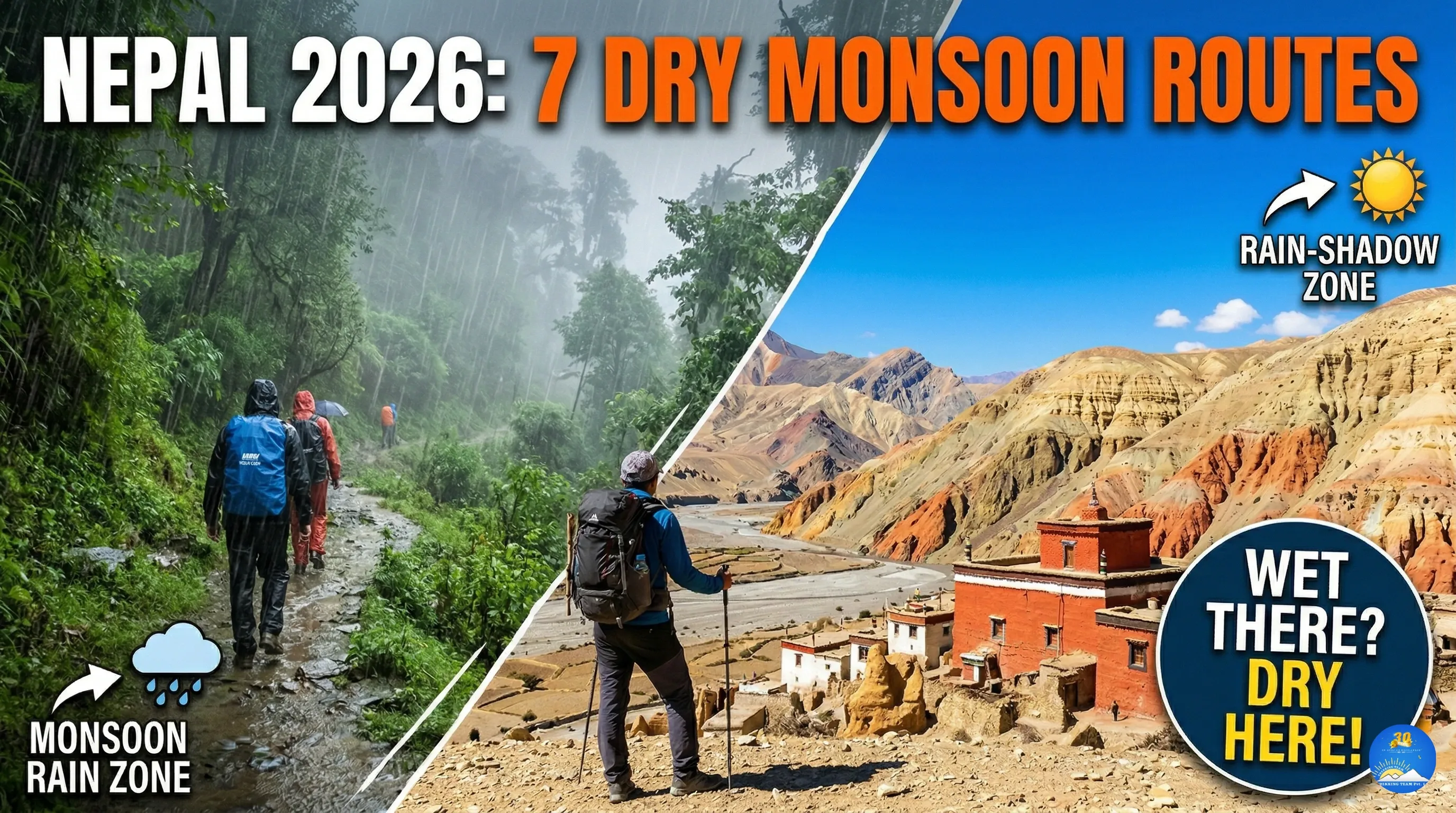
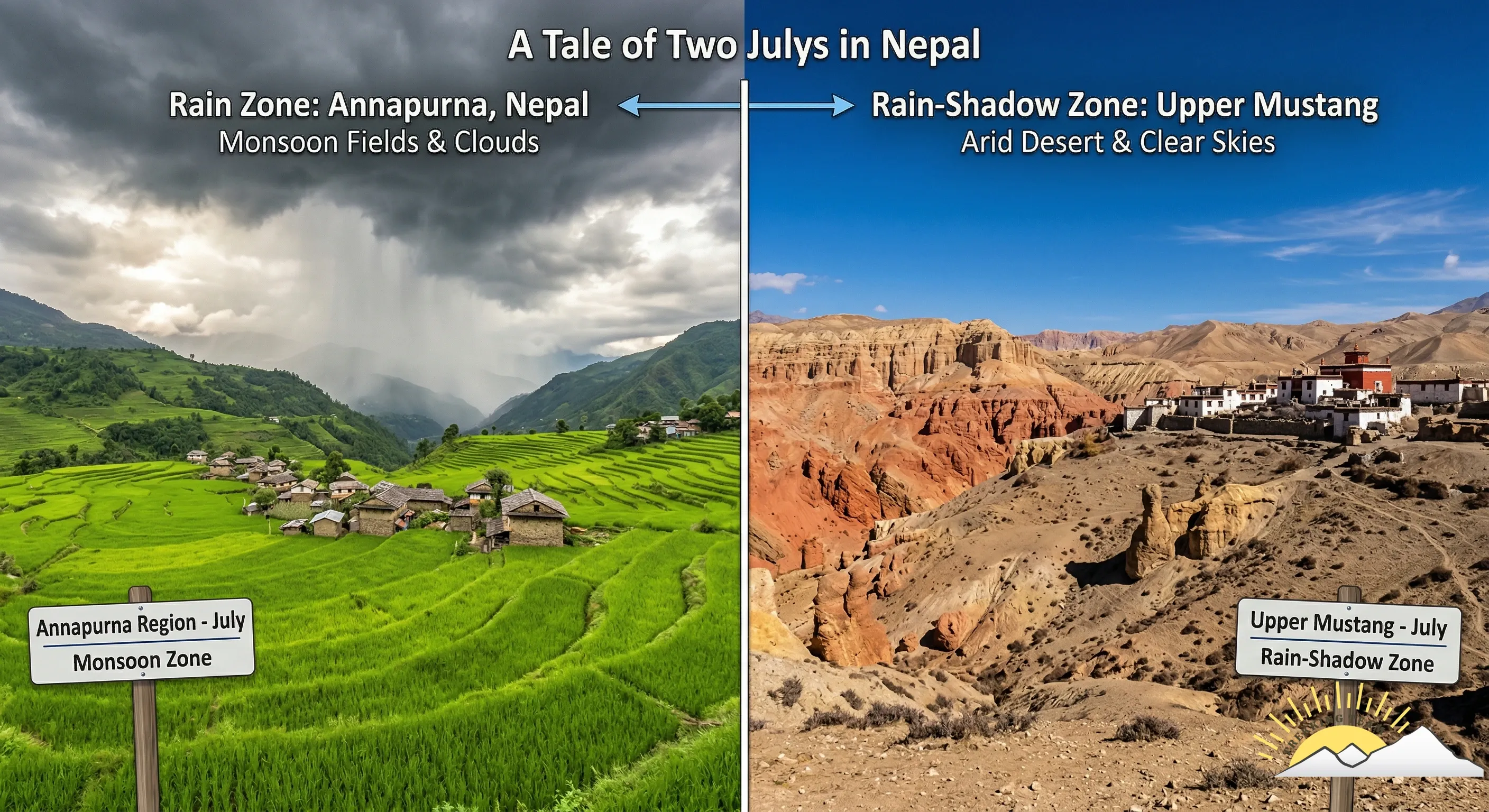
But there is an entire category of Nepal trekking that most operators barely mention routes that sit behind the main Himalayan barrier, in what geographers call the rain shadow. These regions receive less annual rainfall than London. While Pokhara drowns under 4,000 millimetres of monsoon rain, Upper Mustang receives 250 to 300 millimetres for the entire year. While Kathmandu's streets flood, the red desert canyons of Dolpo bake under blue skies.
This guide covers every rain-shadow route we operate during monsoon season, written from direct experience accumulated over three decades not from research, not from other blogs, but from walking these trails ourselves in June, July, August, and September, year after year.
Nepal's 7 Best Monsoon Treks at a Glance
| # | Trek | Duration | Max Elevation | Difficulty | Monsoon Rating |
|---|---|---|---|---|---|
| 1 | Upper Mustang | 12–16 days | 3,810 m | Moderate | ★★★★★ Best season |
| 2 | Upper Dolpo | 18–25 days | 5,190 m | Strenuous | ★★★★★ Best season |
| 3 | Lower Dolpo & Phoksundo | 10–14 days | 3,660 m | Moderate | ★★★★☆ Excellent |
| 4 | Nar Phu Valley | 10–14 days | 5,320 m | Moderate–Strenuous | ★★★★☆ Excellent |
| 5 | Tsum Valley | 12–16 days | 3,700 m | Moderate | ★★★★☆ Very Good |
| 6 | Manang Valley (N. Annapurna) | 7–10 days | 3,519 m | Moderate | ★★★☆☆ Good |
| 7 | Simikot & Humla | 14–20 days | 4,500+ m | Strenuous | ★★★☆☆ Good |
Key 2026 updates: Solo trekkers can now obtain restricted area permits (no 2-person minimum). Upper Mustang permit changed to USD 50/day. TIMS card abolished. Full 2026 regulations →
Why Monsoon Is Nepal's Best-Kept Trekking Secret
Before we list the routes, you need to understand why monsoon trekking is not just "acceptable" but genuinely exceptional:
You will have the trails almost entirely to yourself. Peak season (October–November) brings thousands of trekkers to Nepal's major routes. Monsoon season brings almost nobody. On our Upper Mustang departures in July 2025, our groups encountered fewer than ten other foreign trekkers over the entire two-week journey. On the Dolpo circuit, we saw zero.
The landscapes are at their most alive. The valleys that do receive rain transform into emerald green , rice paddies glow, waterfalls that are thin trickles in autumn become thundering cascades, wildflowers blanket alpine meadows, and the rhododendron forests below 3,000 metres are dense, misty, and atmospheric in a way that dry-season visitors never experience.
Prices drop significantly. Teahouse accommodation, guide fees, domestic flights, and hotel rates in Kathmandu and Pokhara are at their lowest during monsoon. A trek that costs USD 2,500 in October may cost USD 1,800 in July for identical services.
Cultural encounters are deeper. With fewer tourists competing for attention, interactions with local communities become more genuine. Festivals like the Yartung Horse Festival in Upper Mustang (August 2026) and monsoon-season Buddhist ceremonies in Dolpo offer cultural experiences that peak-season crowds never access.
The photography is extraordinary. Dramatic cloud formations, rain-washed clarity in the mornings, vivid green valleys against arid desert ridgelines — photographers who trek during monsoon consistently produce their most striking work.
The Science: Why Some Places Stay Dry
The Himalayan rain shadow is not a vague concept , it is a precise meteorological phenomenon with measurable effects.
Monsoon winds carry moisture northward from the Bay of Bengal. When these air masses hit the southern slopes of the Himalayan range — the highest mountain barrier on Earth — they are forced upward. As the air rises, it cools and releases its moisture as rain. This is why Pokhara (south of the Annapurna range) receives approximately 4,000 mm of rain annually, most of it between June and September.
By the time the air crosses the highest peaks and descends on the northern side, it has lost almost all its moisture. The descending air actually compresses and warms, absorbing remaining moisture from the landscape below. The result: regions immediately north of the main Himalayan crest are arid deserts.
The numbers tell the story:
| Location | Position | Annual Rainfall |
|---|---|---|
| Pokhara | South of Annapurna | ~4,000 mm |
| Lumle (near Pokhara) | Himalayan foothills | ~5,500 mm (wettest place in Nepal) |
| Jomsom (Lower Mustang) | Behind Annapurna/Dhaulagiri | ~260 mm |
| Lo Manthang (Upper Mustang) | Deep rain shadow | ~250–300 mm |
| Upper Dolpo | Behind Dhaulagiri | ~200–250 mm |
| London, UK | For comparison | ~600 mm |
Upper Mustang receives less than half the annual rainfall of London. That is not a marketing exaggeration — it is data from the Nepal Department of Hydrology and Meteorology's weather station in Chhosare, Lo Manthang.
This means that the trails in Upper Mustang, Dolpo, Nar Phu Valley, and Tsum Valley are not merely "manageable" during monsoon — they are genuinely dry, sunny, and warm. Monsoon is arguably their best season.
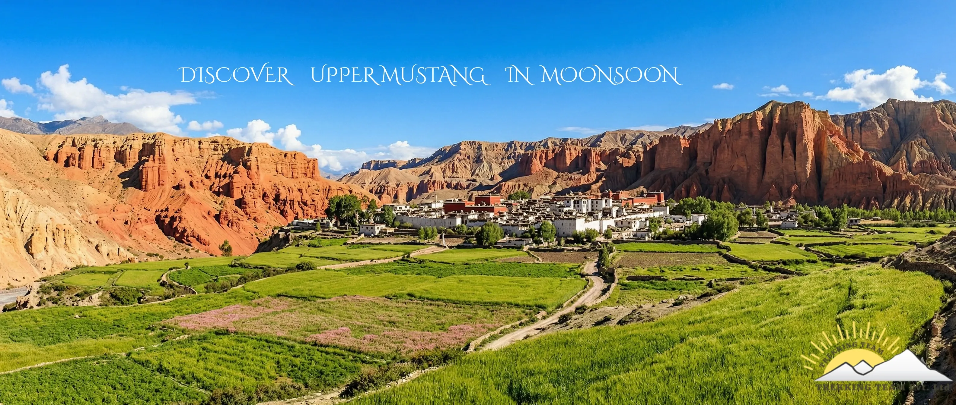
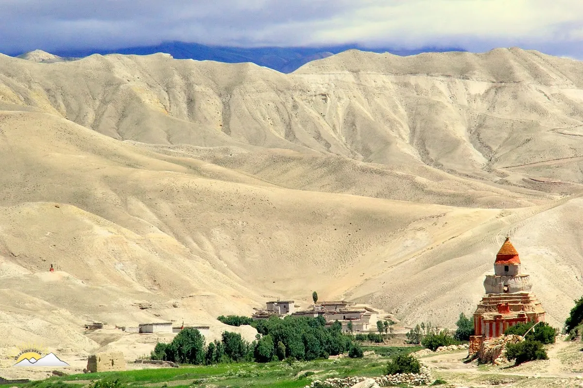
Route 1: Upper Mustang — The Forbidden Kingdom in Its Finest Season
Duration: 12–16 days from Kathmandu Max elevation: 3,810 m (Lo Manthang) Difficulty: Moderate Monsoon rainfall: Minimal — clear mornings, occasional afternoon clouds Solo trekking: Now permitted with licensed guide (March 2026 update — read our full solo trekking guide) Best months: June, July, August
If we could recommend only one monsoon trek, it would be Upper Mustang without hesitation. We have been operating this route since the restricted area opened to foreigners in 1992 — one of the first agencies to receive permits — and after 34 years of guiding clients through the Kali Gandaki valley and into the walled city of Lo Manthang, we can say with complete confidence: monsoon is when Upper Mustang is at its absolute best.
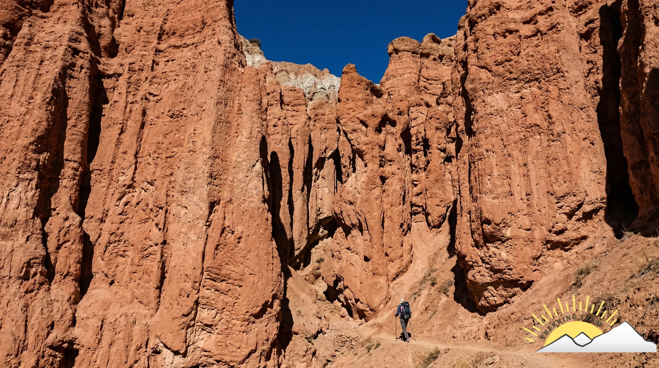
The landscape is a high-altitude desert that looks more like the Tibetan Plateau than tropical Nepal. Red sandstone cliffs, eroded canyons, sky caves carved into cliffsides, whitewashed monasteries perched on ridgelines, and vast open plateaus under blue skies that seem impossibly deep at 3,500 metres. While the rest of Nepal is drenched, Upper Mustang is warm, dry, and spectacular.
Upper Mustang Weather in July and August
This is the question people search for most — and the answer is why Upper Mustang is our number one monsoon recommendation.
| Month | Daytime Temp | Nighttime Temp | Rainfall | Sky Conditions |
|---|---|---|---|---|
| June | 18–28°C | 0–5°C | ~30 mm total | Clear mornings, occasional afternoon cloud |
| July | 20–28°C | 2–7°C | ~35 mm total | Clear mornings, brief afternoon cloud build-up |
| August | 18–26°C | 0–5°C | ~30 mm total | Clear mornings, some afternoon cloud, occasional light drizzle |
| September | 16–24°C | -2–3°C | ~20 mm total | Increasingly clear, excellent visibility |
For comparison: Pokhara receives 800–1,000 mm in July alone. Upper Mustang receives approximately 35 mm in the same month. You are trekking in what is effectively a warm, high-altitude desert.
Morning conditions are almost always clear — this is when you get the sharpest views of Nilgiri, Dhaulagiri, and the surrounding peaks. Afternoon cloud build-up is common but rarely produces rain in the rain-shadow zone. Strong winds are typical in the afternoon through the Kali Gandaki valley (this happens in every season, not just monsoon), so most trekking is done before noon.
What makes monsoon special here:
The Yartung Horse Festival — a centuries-old celebration featuring horse racing, traditional dancing, and community feasting — takes place in Lo Manthang during August. This is one of the most authentic cultural events in the Himalaya, and monsoon trekkers have front-row access without peak-season crowds.
The apple orchards of Marpha are in full fruit. The barley fields around Lo Manthang are green. The ancient mud-brick architecture — which is actually threatened by increasing rainfall due to climate change — is at its most photogenic against the blue sky and red earth.
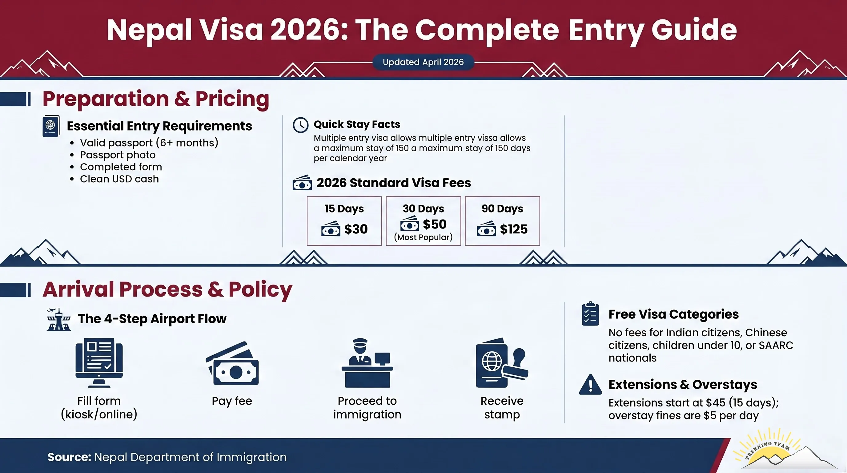
2026 Permit Update:
The old permit system (USD 500 flat fee for 10 days) has been replaced. The current rate is USD 50 per person per day (minimum 2 days). This is significantly more flexible — a shorter 5-day exploration costs USD 250 in permit fees instead of the old USD 500.
As of March 2026, solo trekkers can now obtain restricted area permits without needing a second foreign trekker. You still need a licensed guide and must book through a registered agency like Trekking Team. Read the full update on solo trekking in restricted areas.
Additional permits required: ACAP permit (NPR 3,000 / ~USD 22) + Green Fee (NPR 1,000).
Route 2: Upper Dolpo — The Most Remote Trek in Nepal
Duration: 18–25 days from Kathmandu Max elevation: 5,190 m (Kang La Pass) Difficulty: Strenuous — experienced trekkers only Monsoon rainfall: Minimal in Upper Dolpo; moderate in approach valleys Solo trekking: Now permitted with licensed guide Best months: June, July, August, September
Upper Dolpo is the most remote inhabited region in Nepal and one of the least-visited places on Earth. It is also where our deepest connection to the Himalayan communities we serve is most visible.
Since 2011, Trekking Team Nepal has partnered with Amici del Dolpo, a Swiss nonprofit organisation, to operate annual medical camps in Upper Dolpo — bringing doctors, medicines, and health services to communities that have no hospital access for months of the year. This partnership is not a marketing exercise. It is a commitment that defines how we operate in this region.
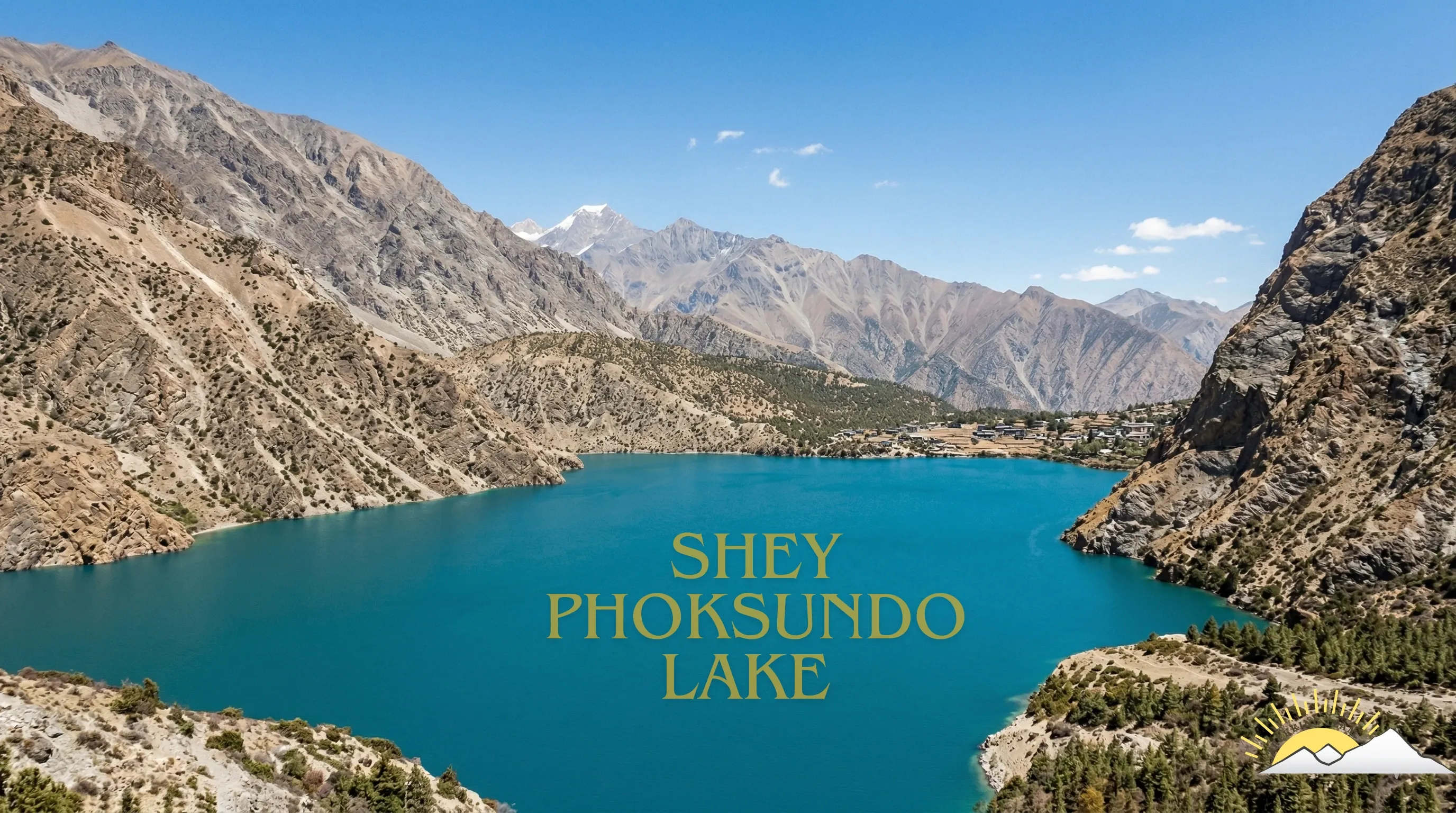
The landscape of Upper Dolpo is otherworldly. Shey Phoksundo Lake — a 5-kilometre-long turquoise lake at 3,611 metres — is one of the deepest and most visually stunning lakes in the Himalayas. The ancient Shey Gompa, the Bonpo and Buddhist monasteries that dot the high valleys, the nomadic yak herders who still follow seasonal migration routes — this is Nepal at its most raw and untouched.
Why monsoon works here: Upper Dolpo sits behind the Dhaulagiri range, deep in the rain shadow. While the approach valleys (particularly the trek from Juphal to Phoksundo) receive some monsoon rain and can be muddy with leeches below 3,000m, once you cross into the Upper Dolpo restricted area the landscape becomes arid and dry. The high passes (Kang La at 5,190m, Numa La at 5,318m) are typically clear of snow in summer, making monsoon one of the only viable seasons for the full Upper Dolpo circuit.
Upper Dolpo Weather During Monsoon
Upper Dolpo receives approximately 200–250 mm of rainfall annually — even less than Upper Mustang. Daytime temperatures in the valleys range from 15–22°C in July and August, dropping to -5–0°C at night above 4,000m. Pass conditions (Kang La, Numa La) are generally favourable in summer: snow is minimal, though cold nights require proper gear. The approach valleys below Phoksundo are the wettest section, with muddy trails and occasional rain for 2–3 days before conditions dry out at higher elevation.
2026 Permits: Restricted Area Permit: USD 50/day. Shey Phoksundo National Park entry permit: NPR 3,000. Solo trekking now permitted. Camping trek — limited teahouse infrastructure. Licensed guide mandatory.
Route 3: Lower Dolpo & Phoksundo Lake — The Accessible Alternative
Duration: 10–14 days from Kathmandu Max elevation: 3,660 m (Phoksundo Lake) Difficulty: Moderate Monsoon rainfall: Some rain in lower sections; dry at Phoksundo Solo trekking: Permitted with licensed guide Best months: June through September
For trekkers who want the Dolpo experience without the 25-day commitment and extreme altitude of Upper Dolpo, the Lower Dolpo circuit to Phoksundo Lake is an exceptional monsoon option.
The trek from Juphal through the Suligad valley to Phoksundo is less demanding than the upper circuit and can be completed in 10–14 days. The lake itself — which Peter Matthiessen made famous in his 1978 book The Snow Leopard — is breathtaking in any season, but during monsoon the surrounding forests are at their most lush and the waterfalls feeding the lake are at full volume.
What to expect: The lower approach valleys will have leeches and muddy trails. Pack leech socks, tuck trousers into boots, and carry salt. Above 3,000m, conditions dry out significantly. At Phoksundo itself, monsoon skies are often clear in the morning with cloud build-up in the afternoon — perfect for photography.
2026 Permits: Lower Dolpo RAP: USD 20/day for the first 10 days, USD 10/day after. Shey Phoksundo National Park permit. Licensed guide mandatory.
Route 4: Nar Phu Valley — The Hidden Gem Behind Annapurna
Duration: 10–14 days from Kathmandu (can combine with Annapurna Circuit) Max elevation: 5,320 m (Kang La Pass, if crossing to Manang) Difficulty: Moderate to Strenuous Monsoon rainfall: Significantly less than southern Annapurna Solo trekking: Now permitted with licensed guide Best months: Late June, July, August, early September
The Nar Phu Valley is a restricted-area side trek off the Annapurna Circuit that sits in a protected rain-shadow pocket between the Annapurna and Manaslu ranges. The twin villages of Nar (4,110m) and Phu (4,080m) are among the most culturally preserved Tibetan Buddhist communities in Nepal — ancient monasteries, prayer wheels lining every path, and a way of life that has changed remarkably little over centuries.
During monsoon, while the standard Annapurna Circuit routes on the southern side are waterlogged and landslide-prone, the Nar Phu Valley remains relatively dry. The valley's position behind Annapurna II and Lamjung Himal blocks the worst of the monsoon moisture, creating conditions that are surprisingly comfortable for trekking.
Why we love this route for monsoon: The villages are small, genuine, and welcoming. The monsoon wildflowers in the meadows approaching Nar are extraordinary. The lack of other trekkers means you have the ancient Tashi Lhakhang Gompa essentially to yourself. And if you're an experienced trekker, crossing the Kang La Pass (5,320m) connects you to Manang and the upper Annapurna Circuit — a route that is feasible in monsoon because the northern side of the circuit sits in a partial rain shadow.
2026 Permits: RAP: USD 100/week (peak season) or USD 75/week (off-season — monsoon qualifies). ACAP permit: NPR 3,000. Solo trekking now permitted.
Route 5: Tsum Valley — The Hidden Valley of Happiness
Duration: 12–16 days from Kathmandu (often combined with Manaslu Circuit) Max elevation: 3,700 m (Mu Gompa) Difficulty: Moderate Monsoon rainfall: Partial rain shadow — less than lower Manaslu approach Solo trekking: Now permitted with licensed guide Best months: Late June, July, September (August can have some rain)
Tsum Valley is a restricted-area sacred valley in the Manaslu region that the Tibetan Buddhist community calls "Beyul" — a hidden valley of happiness. It was only opened to foreign trekkers in 2008, and it remains one of the least-visited trekking destinations in Nepal.
The valley sits north of the main Himalayan crest in a partial rain shadow. While the lower approach through the Budhi Gandaki gorge does receive monsoon rain (and can be challenging with river swelling and landslide risk), the upper Tsum Valley — where the ancient monasteries of Mu Gompa and Rachen Gompa sit — receives significantly less precipitation.
Monsoon advantage: The monastery festivals in Tsum Valley often occur during summer months, and visiting during monsoon gives you access to religious ceremonies and cultural events that peak-season trekkers miss entirely. The valley's isolation means that even in peak season it sees fewer than 1,000 visitors per year — during monsoon, you may be the only foreigner in the entire valley.
2026 Permits: RAP: USD 50/week. Manaslu Conservation Area Permit (MCAP). Licensed guide mandatory. Solo trekking now permitted.
Route 6: Manang Valley (Northern Annapurna Circuit) — The Rain-Shadow Side
Duration: 7–10 days from Kathmandu (Manang section only) Max elevation: 3,519 m (Manang village) Difficulty: Moderate Monsoon rainfall: Significantly less than southern Annapurna Best months: Late June, July, August, September
Not a restricted area — but still rain-shadow. The Manang district, sitting directly behind the Annapurna range, receives approximately 500 mm of annual rainfall compared to the 4,000+ mm that falls on the southern slopes. This makes the upper (northern) section of the Annapurna Circuit — from Chame to Manang and the surrounding day-hike destinations — surprisingly viable during monsoon.
The key is accessing Manang from the east (driving via Besisahar and the Marsyangdi valley) rather than attempting to cross Thorong La from the west. The pass itself can be unpredictable during monsoon, and the western approach receives more rain. But the Manang valley, with its Tibetan-influenced villages, ancient monasteries, and stunning views of Annapurna III and Gangapurna, offers a genuine mountain experience with far fewer logistical challenges than restricted-area treks.
Day hikes from Manang that work in monsoon: Ice Lake (4,620m), Praken Gompa, Gangapurna Lake, and the Khangsar valley. Mornings are typically clear, with cloud build-up after noon.
2026 Permits: ACAP permit: NPR 3,000. No restricted area permit needed. Licensed guide mandatory per 2026 regulations.
Route 7: Simikot & Humla — The Far West Frontier
Duration: 14–20 days from Kathmandu Max elevation: 4,500+ m (varies by route) Difficulty: Strenuous Monsoon rainfall: Partial rain shadow in upper valleys Best months: July, August, September
Nepal's far-western Humla district, accessed via a flight to Simikot, is the starting point for both the Limi Valley trek and the Nepal-side approach to Mount Kailash in Tibet. This region is rarely mentioned in monsoon trekking guides because it is remote, logistically challenging, and requires experienced trekkers — but it is precisely these qualities that make it extraordinary.
The upper valleys of Humla sit in a partial rain shadow behind the Api and Saipal ranges. While the lower approach valleys receive monsoon rain, the higher inhabited valleys around Simikot and the Limi Valley (which borders Tibet) are significantly drier. The monsoon also coincides with the period when 97 peaks in the far-western Karnali and Sudurpaschim provinces are available for climbing with zero permit fees (a Nepal government promotion running through 2027).
2026 connection: Nepal's policy of waiving climbing permit fees for 97 western peaks through 2027 makes this region particularly attractive for trekker-climbers who want to combine a cultural trek with a summit attempt.
What Every Competitor Gets Wrong (And We Get Right)
We reviewed every monsoon trekking article currently ranking on Google. Here is what they consistently get wrong and what 34 years of operating these routes has taught us:
Wrong: "You need at least two foreign trekkers for restricted area permits." Right: As of March 2026, solo trekkers CAN obtain restricted area permits for Upper Mustang, Dolpo, Nar Phu, and Tsum Valley. The two-person minimum has been removed. You still need a licensed guide and must book through a registered agency. Read the full update.
Wrong: "Upper Mustang permit costs USD 500 for 10 days." Right: The permit system changed. The current rate is USD 50 per person per day (minimum 2 days). This makes shorter explorations far more accessible. A 5-day visit costs USD 250 in permits, not USD 500. See our complete 2026 permit guide.
Wrong: "TIMS card required for all treks." Right: The TIMS card system has been abolished. Local municipality permits have replaced it. Full details in our Nepal Trekking Rules 2026 guide.
Wrong: "Monsoon is off-season, so infrastructure is closed." Right: On our core monsoon routes (Upper Mustang, Lower Dolpo), teahouses remain open and operational throughout summer. Upper Mustang, in particular, has excellent teahouse infrastructure that operates year-round. Upper Dolpo is a camping trek regardless of season — infrastructure is not season-dependent.
Wrong: "Flights are unreliable during monsoon." Right: Flights to Jomsom (the gateway to Upper Mustang) are actually more reliable than flights to Lukla during monsoon, because the Kali Gandaki valley creates its own weather patterns. Morning flights typically operate; afternoon flights are affected by wind (this is true in every season, not just monsoon). Flights to Juphal (Dolpo gateway) are less reliable and require buffer days — we always build these into our itineraries.
Monsoon Trekking: The Practical Guide
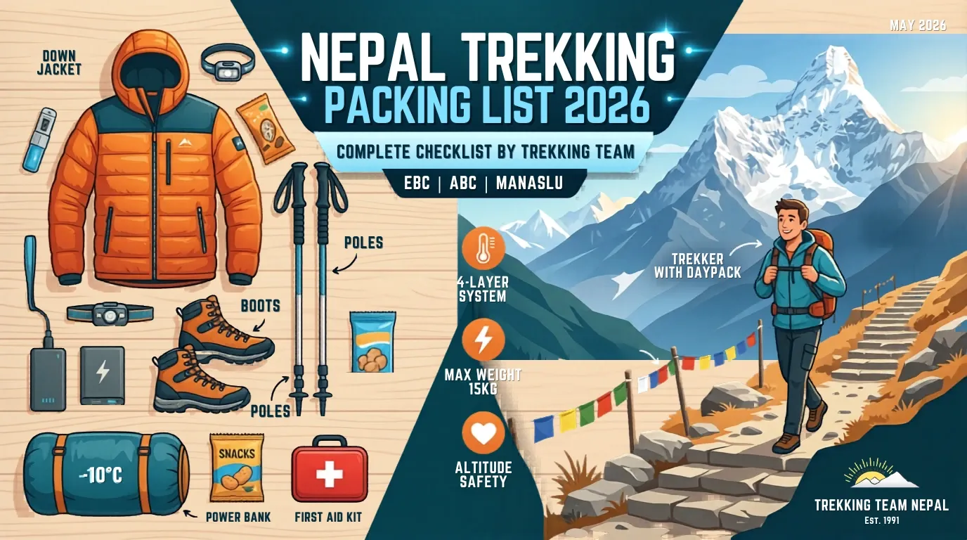
What to Pack (That You Wouldn't Need in Autumn)
Essential monsoon additions:
- Waterproof jacket (Gore-Tex or equivalent) with sealed seams — for approach valleys, not rain-shadow areas
- Waterproof pack cover or dry bags for electronics and documents
- Leech socks or gaiters for trails below 3,000m
- DEET-based insect repellent for boots and lower legs
- Quick-dry clothing — avoid cotton entirely; it absorbs moisture and doesn't dry in humid conditions
- Waterproof stuff sacks for sleeping bag and spare clothing
- Trekking umbrella — surprisingly useful and used by all local porters and guides
- Salt (a small bag) — for leech removal if needed
- Sandals or camp shoes — for river crossings and wet teahouse floors
What you do NOT need extra of: On rain-shadow routes (Upper Mustang, Upper Dolpo, Nar Phu above 3,500m), monsoon gear is barely used. The trails are dry. You may see a brief afternoon shower once or twice in a two-week trek, but nothing that a standard rain jacket can't handle. The gear list above is primarily for the approach valleys at lower elevations.
Leeches: The Truth
Leeches are the number-one concern that stops people from trekking during monsoon. Here is what 34 years of experience tells us:
Above 3,000 metres, leeches are extremely rare to non-existent. The terrain is too dry and too cold. Rain-shadow treks like Upper Mustang, Upper Dolpo, and the upper Nar Phu Valley are essentially leech-free even during peak monsoon.
Below 3,000 metres, in damp forest zones, leeches are present from June through September. They are small (1-3 cm), painless when they attach, and completely harmless — they do not transmit diseases. They are an annoyance, not a danger.
Prevention: Tuck trousers into socks. Apply DEET to boots and lower legs. Wear gaiters if you have them. Check your boots, socks, and legs at every rest stop.
If one attaches: Do not pull it off. Apply salt, and it will release immediately. The bite may bleed for 20-30 minutes afterwards (leeches inject an anticoagulant) — this is normal and not cause for concern. Clean the bite, apply antiseptic, and continue.
On our monsoon Upper Mustang treks, most clients encounter zero leeches for the entire journey. On Lower Dolpo approaches, clients may encounter them for 2-3 days in the lower forest sections before climbing above the leech zone.
Flights and Logistics
Jomsom flights (for Upper Mustang): Morning flights from Pokhara to Jomsom typically operate during monsoon. The Kali Gandaki valley wind pattern means mornings are calm and flyable; afternoons are windy regardless of season. We schedule morning flights and always include one buffer day in case of weather delays.
Juphal flights (for Dolpo): Less reliable during monsoon. We build 1-2 buffer days into every Dolpo itinerary. Alternative road access from Nepalgunj has improved but remains rough during monsoon.
Kathmandu to Pokhara: The road is operational throughout monsoon. Minor landslides occasionally cause short delays. Flights between Kathmandu and Pokhara (25 minutes) are generally reliable.
Domestic flight tip: Book flexible tickets through your agency. During monsoon, weather delays are common and rebooking needs to be handled locally.
Acclimatization During Monsoon
Altitude affects you identically in every season — monsoon does not change the physiology of acclimatization. The same rules apply: ascend gradually above 3,000m, take rest days, hydrate extensively, and watch for symptoms of altitude sickness. Our guides carry pulse oximeters and check blood oxygen levels twice daily on all treks.
The one difference: slightly warmer temperatures during monsoon can make the body feel slightly better at altitude compared to cold-season trekking, as the cardiovascular system doesn't have to work as hard to stay warm. Some trekkers report easier acclimatization in summer months, though individual variation is significant.
Monsoon Trek Costs 2026
| Cost Component | Upper Mustang (14 days) | Lower Dolpo (12 days) | Nar Phu Valley (12 days) |
|---|---|---|---|
| Restricted Area Permit | USD 50/day × 10 days = $500 | USD 20/day × 10 = $200 | USD 100/week × 2 = $200 |
| National Park / Conservation Area | ~$22 (ACAP) | ~$22 (SPNP) | ~$22 (ACAP) |
| Green Fee | ~$7 | — | ~$7 |
| Guide (licensed) | $30–35/day | $30–35/day | $30–35/day |
| Porter | $20–25/day | $20–25/day | $20–25/day |
| Teahouse accommodation | $5–15/night | Camping (included) | $5–15/night |
| Meals on trek | $15–25/day | Included (camping) | $15–25/day |
| Domestic flights | $200–300 | $300–400 | $200–300 |
| Approximate total (per person) | $1,800–2,500 | $2,200–3,000 | $1,500–2,200 |
Monsoon savings vs. peak season: Teahouse rates, guide fees, and domestic flight prices are typically 10-20% lower during monsoon. Hotel rates in Kathmandu and Pokhara can be 30-50% lower. Overall, expect to save USD 200-500 compared to an identical itinerary in October.
For a detailed breakdown of how trekking costs work in Nepal, see our complete Everest Base Camp Trek Cost 2026 guide — the cost structure and permit system applies similarly across all regions.
Month-by-Month Monsoon Guide
June: The Monsoon Arrives
The monsoon typically reaches Kathmandu in the first or second week of June. Southern regions begin receiving heavy afternoon rain. Rain-shadow areas remain dry.
Trail conditions: Upper Mustang — excellent. Warm days (18–28°C), clear mornings, occasional afternoon clouds. Dolpo — accessible; lower approach valleys may be damp. Nar Phu — good conditions above 3,500m.
Crowds: Very few trekkers. You will have trails largely to yourself.
Our recommendation: June is an excellent month for Upper Mustang. The spring crowds have departed, the monsoon has not deterred the adventurous, and the weather in the rain shadow is warm and stable.
July: Peak Monsoon
The wettest month across most of Nepal. Heavy daily rain in Kathmandu, Pokhara, and all southern valleys. Rivers swell. Roads can be affected by landslides.
Trail conditions: Upper Mustang — excellent. This is arguably the single best month for Upper Mustang trekking. Lo Manthang under blue skies with green barley fields and red desert cliffs. Dolpo — conditions are good in Upper Dolpo; the Juphal approach requires careful planning. Nar Phu — good in the upper valley.
Crowds: The lowest of the year. On some routes you will see no other foreign trekkers for days.
Festival: Preparations for the Yartung Horse Festival begin in Lo Manthang.
August: Warm, Dry, and Cultural
Similar conditions to July in rain-shadow areas. The monsoon begins to show subtle signs of weakening by late August.
Trail conditions: Upper Mustang — excellent. Warm and dry. Upper Dolpo — the high passes are at their most snow-free, making the full circuit most feasible. Nar Phu — continuing good conditions.
Festival highlight: The Yartung Horse Festival in Lo Manthang (mid-August 2026) — traditional horse racing, masked dances, and community celebrations in the ancient walled city. This is one of the most authentic cultural events accessible to foreign trekkers anywhere in the Himalayas. We time specific monsoon departures to coincide with this festival.
September: The Transition
The monsoon begins to retreat in the second half of September. Rain becomes less frequent across all regions. By late September, even the southern slopes begin to dry out, and the classic autumn trekking season begins.
Trail conditions: All rain-shadow routes are excellent. Additionally, Manaslu Circuit (upper sections), Langtang Valley, and late-September EBC departures become feasible again.
Our recommendation: September is the most versatile monsoon month. You get the emptiness and low prices of monsoon with improving weather, making it an ideal time for trekkers who want monsoon advantages without full monsoon commitment. Rain-shadow routes are at their best, and by late September, the standard routes begin opening up.
Frequently Asked Questions
Is it safe to trek in Nepal during monsoon? On rain-shadow routes — Upper Mustang, Dolpo, Nar Phu, Tsum Valley — yes, absolutely. These trails are dry, well-maintained, and operated safely throughout monsoon season. We do NOT recommend Everest Base Camp, Annapurna Base Camp, or the lower Annapurna Circuit during June-August due to genuine safety risks (landslides, flooding, poor visibility). Read our complete Nepal trekking rules guide for current safety information.
Can I trek solo in restricted areas during monsoon 2026? Yes. As of March 2026, the two-person minimum for restricted area permits has been removed. A single trekker can now obtain permits for Upper Mustang, Dolpo, Nar Phu, and Tsum Valley — provided they hire a licensed guide and book through a registered agency. Full solo trekking update here.
How much does the Upper Mustang permit cost in 2026? USD 50 per person per day (minimum 2 days). The old flat rate of USD 500 for 10 days no longer applies. This makes shorter visits much more affordable. Complete 2026 permit details here.
Will I encounter leeches? On rain-shadow routes above 3,000m — no. Leeches are present in lower-elevation forest zones (below 3,000m) during June-September. They are harmless but can be prevented with proper clothing and DEET application.
Are teahouses open during monsoon? In Upper Mustang — yes, all teahouses operate year-round. In Nar Phu and Tsum Valley — most teahouses operate during monsoon, though some smaller ones may close. In Upper Dolpo — this is a camping trek regardless of season.
Do flights operate during monsoon? Yes, with caveats. Morning flights to Jomsom (Upper Mustang gateway) are generally reliable. Flights to Juphal (Dolpo) are less reliable and require buffer days. We always include contingency days in our monsoon itineraries.
What is the best monsoon trek for beginners? Upper Mustang. The maximum altitude is approximately 3,810m (lower than most major treks), the terrain is moderate, and teahouse infrastructure is excellent. The trail is well-defined and does not require technical skills. The dry, clear conditions make it comfortable for first-time trekkers.
Is monsoon the best time for Upper Mustang? Many experienced operators — including us — believe yes. The warm temperatures, dry conditions, lack of crowds, lower prices, green barley fields, and access to the Yartung Horse Festival make monsoon arguably the single best season for Upper Mustang.
Why Trek Monsoon with Trekking Team Nepal
We are not a company that discovered rain-shadow trekking last year. We have been operating Upper Mustang since 1992 and Dolpo routes since the mid-1990s. Our connection to these regions goes beyond tourism:
Upper Mustang: We were among the first agencies to receive permits when Upper Mustang opened to foreigners in 1992. Our guides know the teahouse owners by name, the best rooms in every lodge, and the local history that no guidebook contains.
Dolpo: Our partnership with Amici del Dolpo — a Swiss nonprofit — has operated annual medical camps in Upper Dolpo since 2011. When we take you to Dolpo, you are walking with a team that has a genuine, ongoing relationship with the communities you visit.
Experience: 34 years. 10,000+ trekkers. TAAN member since 1991. PPGI member (porter welfare). Netflix Singapore documentary collaboration. This is not our first monsoon season. It is our thirty-fourth.
All permits included. Every Trekking Team monsoon package includes all required permits — restricted area permits, conservation area fees, the new Green Fee, and guide services. You do not need to visit any government office yourself.
Book Your Monsoon 2026 Trek
Monsoon departures for Upper Mustang, Lower Dolpo, and Nar Phu Valley are now open for June through September 2026. Solo trekkers are welcome on all restricted-area routes — no partner required.
🎧 Listen to our podcast on Spotify for deeper conversations about monsoon trekking and trail stories from 34 years in the Himalayas.
📺 Watch our altitude sickness prevention video on YouTube — essential viewing before any high-altitude trek.
Get in touch:
- Visit: trekkingteam.com
- WhatsApp: +977 9869400739/+977 9851037717
- Email: info@trekkingteam.com
- Office: Gongabu, Pragatinagar, Kathmandu, Nepal
Walking Nepal's trails in every season since 1991.
Best monsoon treks in Nepal 2026: Upper Mustang, Dolpo, Nar Phu & more. Rain-shadow routes with clear skies while the rest of Nepal is wet. Solo permits now available. 34 years of monsoon trekking expertise.